


PRECINCT COT 1, Mahoning County, Ohio
About
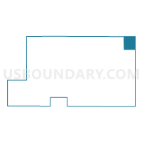
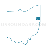
Outline

Summary
| Unique Area Identifier | 649539 |
| Name | PRECINCT COT 1 |
| County | Mahoning County |
| State | Ohio |
| Area (square miles) | 7.66 |
| Land Area (square miles) | 7.63 |
| Water Area (square miles) | 0.02 |
| % of Land Area | 99.70 |
| % of Water Area | 0.30 |
| Latitude of the Internal Point | 41.11273190 |
| Longtitude of the Internal Point | -80.53292720 |
Maps

Graphs
Select a template below for downloading or customizing gragh for PRECINCT COT 1, Mahoning County, Ohio


Neighbors
Neighoring Voting District (by Name) Neighboring Voting District on the Map
- HUBBARD TWP B Voting District, Trumbull County, OH
- HUBBARD TWP C Voting District, Trumbull County, OH
- PRECINCT COT 2, Mahoning County, OH
- PRECINCT YGN2 B, Mahoning County, OH
- PRECINCT YGN2 G, Mahoning County, OH
- PULASKI TWP VTD 02, Lawrence County, PA
- SHENANGO TWP VTD WEST, Mercer County, PA
Top 10 Neighboring County Subdivision (by Population) Neighboring County Subdivision on the Map
- Youngstown city, Mahoning County, OH (66,971)
- Hubbard township, Trumbull County, OH (13,528)
- Shenango township, Mercer County, PA (3,929)
- Pulaski township, Lawrence County, PA (3,452)
- Coitsville township, Mahoning County, OH (1,392)
Top 10 Neighboring Place (by Population) Neighboring Place on the Map
Top 10 Neighboring Unified School District (by Population) Neighboring Unified School District on the Map
- Youngstown City School District, OH (69,017)
- Hubbard Exempted Village School District, OH (13,576)
- Wilmington Area School District, PA (11,828)
- West Middlesex Area School District, PA (7,454)
Top 10 Neighboring State Legislative District Lower Chamber (by Population) Neighboring State Legislative District Lower Chamber on the Map
- State House District 65, OH (102,284)
- State House District 60, OH (95,158)
- State House District 7, PA (56,775)
- State House District 9, PA (56,261)
Top 10 Neighboring State Legislative District Upper Chamber (by Population) Neighboring State Legislative District Upper Chamber on the Map
- State Senate District 33, OH (323,425)
- State Senate District 32, OH (311,809)
- State Senate District 50, PA (235,966)
- State Senate District 47, PA (225,797)
Top 10 Neighboring 111th Congressional District (by Population) Neighboring 111th Congressional District on the Map
Top 10 Neighboring Census Tract (by Population) Neighboring Census Tract on the Map
- Census Tract 327.01, Mercer County, PA (4,792)
- Census Tract 9315, Trumbull County, OH (3,906)
- Census Tract 104, Lawrence County, PA (3,452)
- Census Tract 8138, Mahoning County, OH (3,067)
- Census Tract 8109, Mahoning County, OH (2,244)
- Census Tract 9317, Trumbull County, OH (2,023)
Top 10 Neighboring 5-Digit ZIP Code Tabulation Area (by Population) Neighboring 5-Digit ZIP Code Tabulation Area on the Map
- 44505, OH (19,357)
- 44425, OH (14,898)
- 16159, PA (4,706)
- 44436, OH (3,836)
- 16143, PA (2,901)
- 16140, PA (123)